The Andatza coarse-grained turbidite system (westernmost Pyrenees): Stratigraphy, sedimentology and structural control
El sistema turbidítico conglomerático de Andatza (Pirineos occidentales): Estratigrafía, sedimentología y control estructural
A. Bodego1, L.M. Agirrezabala2
1 Dept. of Mining and Metallurgic Engineering and Material Science, Engineering School of Bilbao, Univ. of the Basque Country (UPV/EHU), 48013 Bilbao. Email: arantxa.bodego@ehu.eus. ORCID ID: http://orcid.org/0000-0003-1825-4239
2 Dept. of Stratigraphy and Palaeontology, Faculty of Science and Technology, Univ. of the Basque Country (UPV/EHU), 48080 Bilbao. Email: l.agirrezabala@ehu.eus. ORCID ID: http://orcid.org/0000-0003-2915-9552
| |
ABSTRACT
This is a field-based work that describes the stratigraphy and sedimentology of the Andatza Conglomerate Formation. Based on facies analysis three facies associations of a coarse-grained turbidite system and the related slope have been identified: (1) an inner fan of a turbidite system (or canyon) and (2) a low- and (3) a high-gradient muddy slope respectively. The spatial distribution of the facies associations and the palaeocurrent analysis allow to interpret a depositional model for the Andatza Conglomerates consisting of an L-shaped, coarse-grained turbidite system, whose morphology was structurally controlled by synsedimentary basement-involved normal faults. The coarse-grained character of the turbidite system indicates the proximity of the source area, with the presence of a narrow shelf that fed the turbidite canyon from the north.
Keywords: coarse-grained turbidite system; Basque-Cantabrian basin; westernmost Pyrenees; Albian.
|
| |
RESUMEN
En este trabajo se describe la estratigrafía y sedimentología de la Formación Conglomerados de Andatza. Mediante el análisis de facies se han interpretado tres asociaciones de facies principales correspondientes a un sistema turbidítico (de grano grueso) y al talud: un sistema turbidítico interno (o cañón), un talud fangoso de alto gradiente y otro de bajo gradiente. La distribución cartográfica de las asociaciones de facies junto con el análisis de paleocorrientes describen un modelo sedimentario de sistema turbidítico de grano grueso en forma de “L” para los Conglomerados de Andatza, cuya morfología fue controlada por fallas normales sinsedimentarias de basamento. El carácter grosero del tamaño de grano de este sistema turbidítico indica la proximidad del área fuente de los conglomerados, que alimentaría el cañón turbidítico desde el norte a través de una estrecha plataforma marina.
Palabras clave: sistema turbidítico conglomerático; cuenca Vasco-Cantábrica; Pirineos occidentales; Albiense.
|
IntroductionTOP
Aptian−Albian basin-margin coarse-grained sedimentary rocks in the Basque-Cantabrian rift basin have usually been interpreted as fan-delta deposits laid down in coastal environments (Andatza Fm; García-Mondéjar, 1982; Monte Grande Fm; Robles et al., 1988a,b; Oiartzun Fm; Fernández-Carrasco et al., 1990a,b), indicating the erosion of an emerged basement adjacent to the coast line. However, Agirrezabala & García-Mondéjar (1994) evidenced that deep-marine coarse-grained sedimentation occurred in the Albian of the Basque-Cantabrian basin (BCB), and suggested the presence of a narrow shelf between the emerged source area and the deep-marine basin. In this work a new sedimentological interpretation for the Andatza Conglomerate Formation (Bodego et al., 2015) is proposed, differing from that of García-Mondéjar (1982), who suggested a fluvial to fan-delta environment for the Andatza conglomerates and located the type series in the vicinity of the Oiartzun locality. However, that succession is nowadays considered to belong to the Oiartzun Formation (Fernández-Carrasco et al., 1990b).
The accurate interpretation of basin margin depositional environments is crucial to understand the tectonosedimentary evolution of rifted margins. In this field-based study, new data based on mapping, stratigraphic correlation and sedimentological analysis is presented, that enable a new depositional model to be proposed for the Andatza Conglomerates during the late Albian−lower Cenomanian of the northeastern BCB margin, to the northwest of the Palaeozoic Bortziriak (Cinco Villas) Massif.
Geological setting and stratigraphyTOP
The Andatza coarse-grained turbidite system crops out in the northeastern margin of the BCB, westernmost Pyrenees. The study area is located in the northwest of the Bortziriak Massif, which is the westernmost Pyrenean Palaeozoic massif (Fig.1a). Basin development was intimately linked to the relative motion of the Iberian and Eurasian plates during the Cretaceous, which was governed by the opening of the North Atlantic Ocean and in turn resulted in the opening of the Bay of Biscay under extensional to transtensional tectonics (e.g. Choukroune & Mattauer, 1978; Montadert et al., 1979; García-Mondéjar et al., 1996; Roca et al., 2011).
|
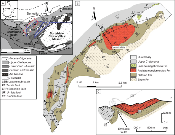 Fig. 1.—Geological setting of the Andatza turbidite system. A. Schematic geological map of the Bortziriak-Cinco Villas Palaeozoic massif showing the location of the study area and the Lasarte sub-basin. B. Geological map of the study area, with indication of the Andatza and Oztaran formations comprised in the Andatza turbidite system. C. Geological cross-section I-I’ is shown in C and the interpreted stratigraphic cross section in figure 3b. A-A’ corresponds to the interpreted stratigraphic cross section in figure 3a. The trend of this section reflects the apparent trace of the submarine slopes. Fig. 1.—Geological setting of the Andatza turbidite system. A. Schematic geological map of the Bortziriak-Cinco Villas Palaeozoic massif showing the location of the study area and the Lasarte sub-basin. B. Geological map of the study area, with indication of the Andatza and Oztaran formations comprised in the Andatza turbidite system. C. Geological cross-section I-I’ is shown in C and the interpreted stratigraphic cross section in figure 3b. A-A’ corresponds to the interpreted stratigraphic cross section in figure 3a. The trend of this section reflects the apparent trace of the submarine slopes.
|
|
In this area, the basement is composed of Palaeozoic (Culm facies) and Triassic (Buntsandstein and Keuper facies) rocks (Campos, 1979). The Palaeozoic rocks are intruded by the Permian Aia granite pluton (Campos, 1979; Pesquera & Pons, 1990; Denelè et al., 2012). Jurassic micritic carbonates and marlstones overlie Triassic rocks (Robles et al., 2004) and are themselves overlain by Lower Cretaceous serpulid-bearing micritic to calcarenitic limestones and marlstones (“Serpulid limestones”, Soler y José, 1972). The main extensional phase occurred during the Aptian−Albian and coincided with a generalized transgression (Haq, 1988) leading to the sedimentation of shallow-marine carbonate-platform and basinal limestones and marlstones and estuarine and shelf sandstones and mudstones during the early Aptian to early Albian. During the late Albian, increasing subsidence led to the deposition of deep-marine sandstones, mudstones, conglomerates and breccias in the deepest basinal areas adjacent to the massif, whereas coetaneous braid-plain delta to shallow-marine conglomerates, sandstones, mudstones and limestones were deposited at the margins of the Palaeozoic massif (Rat, 1959; Bodego et al., 2015). Finally, Upper Cretaceous hemipelagic marlstones and limestones overlie the described sedimentary succession.
Early Cretaceous tectonics resulted in the development of a number of local depocentres and extensional sub-basins (e.g. García-Mondéjar et al., 1996), one of which is the Lasarte sub-basin (LSB, Fig. 1a; Bodego & Agirrezabala, 2013). This triangular-shaped sub-basin is bordered by three main basement-involved synsedimentary normal faults: the E−W-trending Errekalde fault to the north, the N−S-trending Zarate fault to the west and the NE−SW-trending Urnieta fault to the southeast (Fig. 1a). The LSB shows a thick (up to 3000 m) Mesozoic succession (Bodego & Agirrezabala, 2013; Bodego et al., 2015).
The Andatza coarse-grained tubidite system comprises the Andatza Conglomerate Formation (García-Mondéjar, 1982) and the upper part of the underlying Oztaran Formation, of latest Albian to early Cenomanian age (Figs. 1b,2) (Bodego et al., 2015). In general, there is no good physical continuity amongst exposures, which are mostly restricted to the northwestern half of the LSB. Coarse-grained rocks (Andatza Fm) crop out in the hanging syncline of the Andatza and Irisasi mountains, whereas the finest-grained units (Oztaran Fm) are restricted to a narrow band, 100-300 m wide, extending from the north of Andatza-Irisasi Mtns to the Andazarrate locality (Fig. 1b). This system unconformably overlies undisturbed bedded mudstones of the Oztaran Fm (U1) and is also unconformably underlain by alternating marls and limestones of the Upper Cretaceous Calcareous Flysch (U2, Figs. 1c, 2 and 3) (Feuillée, 1967; Mathey, 1987).
|
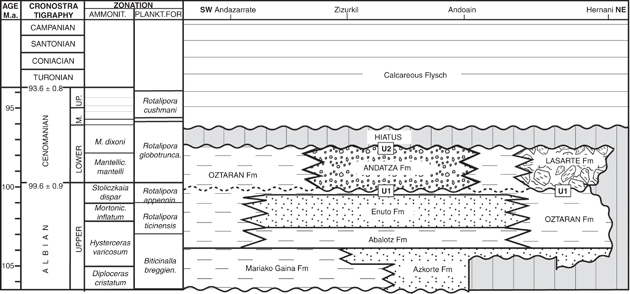 Fig. 2.—SW-NE chronostratigraphic chart of the Lasarte sub-basin (study area) with indication of the formations of the Andatza turbidite system and adjacent slopes (after Bodego et al., 2015). Fig. 2.—SW-NE chronostratigraphic chart of the Lasarte sub-basin (study area) with indication of the formations of the Andatza turbidite system and adjacent slopes (after Bodego et al., 2015).
|
|
|
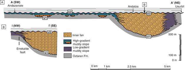 Fig. 3.—Interpreted stratigraphic cross sections showing the inferred lithostratigraphic architecture of the Andatza turbidite system. Note the dramatic lateral thickness and facies changes. A. SW−NE section across the Zarate fault. B. NW−SE section across the Errekalde fault. Intersection point indicated in A. Fig. 3.—Interpreted stratigraphic cross sections showing the inferred lithostratigraphic architecture of the Andatza turbidite system. Note the dramatic lateral thickness and facies changes. A. SW−NE section across the Zarate fault. B. NW−SE section across the Errekalde fault. Intersection point indicated in A.
|
|
A minimum thickness of 550 m can be estimated for the Andatza Fm in the Andatza hanging-syncline, since its upper part is missing because of the present-day erosion level (Figs. 1c and 3). To the northeast, the thickness decreases to 400 m, and to the north, northwest, and southwest the succession thins dramatically to 50−75 m (Fig. 3).
Facies analysisTOP
The facies analysis has resulted in five deep-water facies, mainly conglomerates, conglomeratic sandstones, sandstones and mudstones. Facies have been described and interpreted following the classifications of Pickering et al. (1986) and Mutti & Ricci Lucchi (1972, 1975), with indication to Lowe (1982) and Mutti (1992), in order to attribute each facies to one or more processes or mechanisms of deposition.
Facies 1: conglomeratesTOP
Conglomerates are polymictic, composed of poorly-sorted, well- to poorly-rounded pebbles to cobbles, up to 7 cm (average 2 cm) in diameter, with medium- to coarse-grained sandy matrix (Figs. 4a,b). Matrix content is variable (matrix- to clast-supported conglomerates) and pebbles and cobbles are composed of palaeozoic hydrothermal quartz, quartzite and shales, and also granule conglomerates, sandstones and mudstones (intraclasts). The conglomerate beds are 0.5−2 m thick and show erosive bases (Figs. 5 and 6) with scarce flute and groove casts. Some beds thin laterally and amalgamation is common, which difficult the recognition of the stratification. Most beds are disorganized, although some show normal and/or inverse grading, and/or planar lamination and clast imbrications. They also contain plant remains.
|
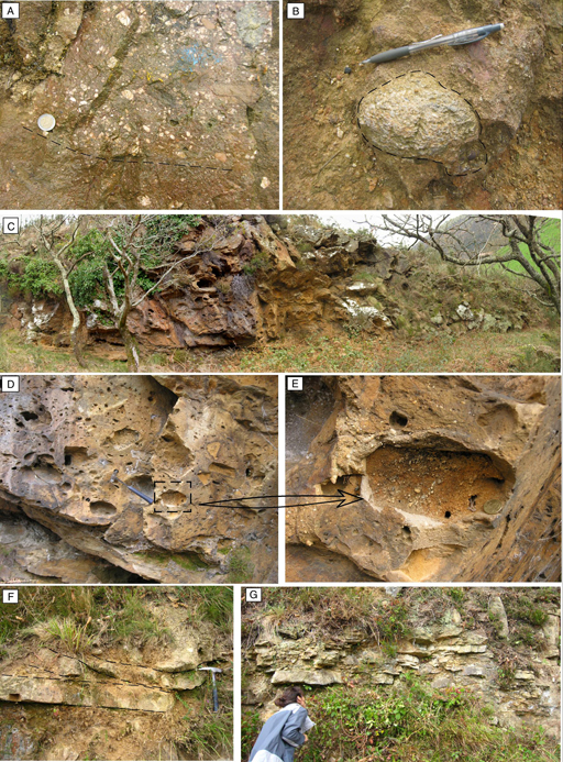 Fig. 4.—Field photographs of the coarsest facies. A. Photograph of the conglomerates of the inner fan facies association. B. Detail of a conglomerate bed showing the size and angular character of a granule-conglomerate clast embedded in a coarse-grained matrix. C. Outcrop example of disorganized sandy conglomerate infill of a gully of the high-gradient slope facies association. D. Disorganized matrix-supported conglomerate to pebbly sandstone. Hollows are clast moulds due to weathering. E. Detail of a cavity left by a weathered clast. A remnant of it is still present, showing a granule conglomerate. Note the bedding of the clast, perpendicular to the conglomerate bedding. F. Example of trough cross-bedded sandstones. G. Sandstone−mudstone alternations. Fig. 4.—Field photographs of the coarsest facies. A. Photograph of the conglomerates of the inner fan facies association. B. Detail of a conglomerate bed showing the size and angular character of a granule-conglomerate clast embedded in a coarse-grained matrix. C. Outcrop example of disorganized sandy conglomerate infill of a gully of the high-gradient slope facies association. D. Disorganized matrix-supported conglomerate to pebbly sandstone. Hollows are clast moulds due to weathering. E. Detail of a cavity left by a weathered clast. A remnant of it is still present, showing a granule conglomerate. Note the bedding of the clast, perpendicular to the conglomerate bedding. F. Example of trough cross-bedded sandstones. G. Sandstone−mudstone alternations.
|
|
|
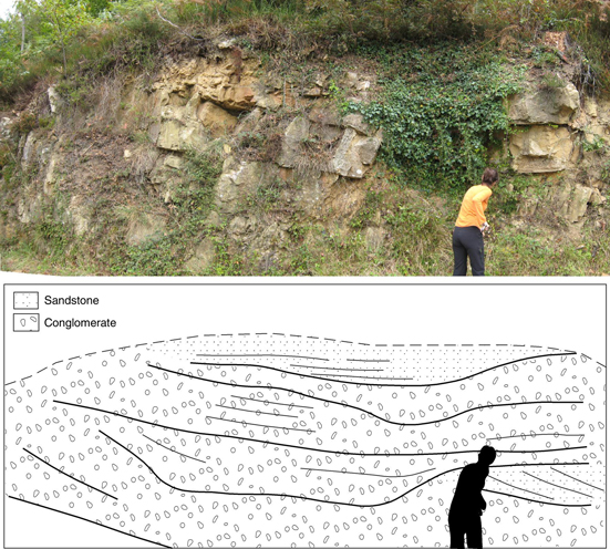 Fig. 5.—Photo and interpretated sketch of the conglomerate and sandstone infill of a channel. Note the bedding geometry. Fig. 5.—Photo and interpretated sketch of the conglomerate and sandstone infill of a channel. Note the bedding geometry.
|
|
|
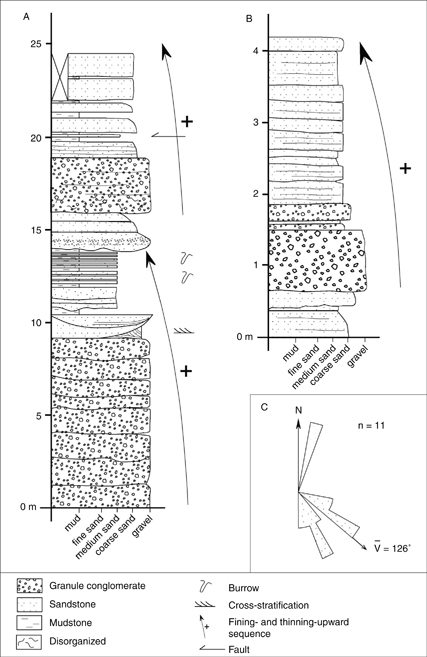 Fig. 6.—A and B. Stratigraphic columns showing the characteristic organization of the inner part of the turbidite system facies associations. C. Rose diagram showing the palaeocurrent distribution. Data have been taken from imbrications, flute and groove casts and trough cross-bedding. Fig. 6.—A and B. Stratigraphic columns showing the characteristic organization of the inner part of the turbidite system facies associations. C. Rose diagram showing the palaeocurrent distribution. Data have been taken from imbrications, flute and groove casts and trough cross-bedding.
|
|
This facies is similar to the A1.1 and A2 facies of Pickering et al. (1986), A1 facies of Mutti and Ricci Lucchi (1972, 1975), R2-3 and S1 of Lowe (1982) and F2-3 of Mutti (1992). The disorganized beds are interpreted as the result of rapid sedimentation from high-density flows, including density-modified debris flows (see also Lowe, 1982), through frictional and/or cohesive freezing. Beds showing internal organization are attributed to sedimentation from high-density flows, which would occur under different ways revealed by the variable internal organization of beds (Lowe, 1982).
Inverse grading of the lower part of beds and imbrications would reflect the formation of traction carpets in the base of the flow, followed its sedimentation through frictional freezing as frictional resistance to motion due to grain interlocking exceeded the shear imparted from the overriding flow. Graded beds in turn would be the result of the rapid deposition from highly concentrated turbidity currents.
The presence of clasts of shales and Carboniferous quartz suggests the weathering and erosion of Palaeozoic massifs. Clasts of granule conglomerates, sandstones and mudstones are similar to the facies of this facies association, which indicates that they are intraclasts.
Facies 2: disorganized conglomeratic sandstoneTOP
Subfacies 2a: poorly-rounded clast-bearingTOP
These consist of poorly-sorted sandstones with a homogeneous distribution of pebbles and cobbles up to 15 cm (average 2−5 cm) in diameter. The beds are up to 2 m thick, with erosional bases, in some cases with a relief of up to few centimetres, and occasionally contain thinner (a few centimetres thick) beds interlayered made up of medium- to coarse-grained sand. Composition of clasts is similar to that of the conglomerate facies (mainly Palaeozoic) and they also contain fossil plant remains.
They correspond to facies A1.4 of Pickering et al. (1986), A2 of Mutti & Ricci Lucchi (1972, 1975), S3 of Lowe (1982) and F5 of Mutti (1992). They are interpreted as deposited by en masse sedimentation from high-density turbidity currents due to the increased intergranular friction as the flows decelerate (Mutti, 1992).
Subfacies 2b: subangular clast-bearingTOP
These consist of coarse- to very-coarse sandstones with subangular clasts (up to 25 cm) of Palaeozoic quartz, quartzites and shales, and intraclasts of granule-bearing sandstones and mudstones (Figs. 4c,d,e). The beds are up to several metres thick with no internal organization and they fill erosional conduits, which are at least up to 40 m deep and 250 m wide. Onlap against scar margins is visible.
They correspond to facies A1.4 of Pickering et al. (1986) and S3 of Lowe (1982) and F5 of Mutti (1992). They are the result of rapid en masse sedimentation of a pebble-sand mixture due to increased intergranular friction as high-concentration flows decelerate (Lowe, 1982). It is interpreted as products of high-density turbidity currents and/or cohesionless (sandy) debris-flows that flowed through the channels and/or gullies.
Facies 3: sandstonesTOP
These are characterized by well-sorted sandstone beds, medium- to coarse-grained, with scarce pebbles usually at the base. The beds are tabular, up to 2 m thick, and show planar to concave-up bottoms (Figs. 5 and 6a,b). They display variable structures: some beds are massive, whereas others display normal and inverse grading. Finally, some others are cross-bedded, forming sets 10−15 cm thick of either high- or low-angle and planar or trough cross-bedding (Figs. 4f,g). Fossil casts (bivalves/ammonites?) have been recognized. Cross-stratification analysis indicates palaeocurrents towards the southeast (Fig. 6c).
Sandstones of this facies are comparable to facies B1-2 of Mutti & Ricci Lucchi (1972, 1975), facies B of Pickering et al. (1986), and facies F5-6 of Mutti (1992). Normal to inverse grading of sandstone beds are interpreted as the result of more of less rapid “freezing” of a high-density turbidity current (Mutti, 1992). The cross-stratified sandstone beds are considered as the product of a hydraulic jump that transforms a supercritical high-density turbidity current into a subcritical, low-density turbidity current. The flow expansion permits coarsest grain population to settle through the flow and be tracted and organized in bed forms along the bottom (Mutti, 1992).
Facies 4: alternating sandstones and mudstonesTOP
This facies is organized in beds between 3 and 20 cm in thickness. The average sandstone to mudstone ratio is about 2:1. Sandstone beds are tabular, made of medium to coarse sand and structureless. Mudstones beds are 2−5 cm in thickness, occasionally silty and they show pervasive bioturbation features (Fig. 6a).
This facies is difficult to adscribe: its ungraded character makes it comparable to facies B.1.2 of Pickering et al. (1986), to facies C1 and E1 of Mutti & Ricci Lucchi (1972, 1975) and to facies F8 of Mutti (1992). It probably reflects sedimentation from relatively dense flows of a more distal character than the facies of the previous group. Sandstone beds are attributed to en masse sedimentation from a turbidity current (Mutti, 1992).
Facies 5: mudstonesTOP
Subfacies 5a: debrite-bearingTOP
These consist of massive dark mudstones with alternating thin (up to few centimetres) sandstone and siltstone beds. Debrite and slump beds up to 10 cm have also been identified. These are characterized by a brecciated texture with intraclasts of mudstones embedded in a sandy-muddy matrix.
Mudstones are similar to facies E of Pickering et al. (1986) and facies G of Mutti & Ricci Lucchi (1972, 1975). Slumps and debrite beds are similar to facies F2 of Pickering et al. (1986) and facies F of Mutti & Ricci Lucchi (1972, 1975). This mudstone facies is interpreted as deposited from suspended fine-grained material in a very low energy environment (facies E/G). Sandstones and siltstones are attributed to diluted turbidity currents, and debrite/slump deposits to submarine landslides, with important internal deformation.
Subfacies 5b: sandstone-bearingTOP
These are massive mudstones or mudstones alternating with very-fine grained siltstone to sandstone laminae. Ocasionally sandstone beds up to 15 cm thick have been observed. The bases of the sandstone beds are either planar or erosive.
It corresponds to facies E of Pickering et al. (1986) and facies G of Mutti & Ricci Lucchi (1972, 1975). Sanstone beds are similar to those of facies D1-3 of Mutti & Ricci Lucchi (1972, 1975) and facies C2.3 and C2.4 of Pickering et al. (1986). They are interpreted to record a setting with mud background sedimentation, into which dilute turbidity currents flow and deposit episodically.
Facies associations and environmentsTOP
The facies identified in the Andatza and uppermost Oztaran formations have been grouped into three facies associations corresponding to a turbidite system and associated slope environments, by means of facies spatial distribution and interpretation of vertical and lateral facies variability. Alpine structural complications and poor exposure have prevented a complete establishment of mutual relationships between the different facies.
Facies association 1: Inner fan of a turbidite systemTOP
This facies association is found in the Andatza Fm. Its outcrops are limited to the Andatza-Irisasi hanging syncline (Figs. 1b,c), where four facies have been distinguished: conglomerates (facies 1), poorly-rounded clast-bearing disorganized conglomeratic sandstones (subfacies 2a), sandstones (facies 3) and alternating sandstone and mudstones (facies 4).
Overall, the abundance of conglomerate facies in this association suggests the predominance of high-density high-momentum flows that transported gravel-sized sediments. Conglomerate, conglomeratic sandstone, sandstone and alternating sandstone and mudstone facies are organized in fining- and thinning-upward sequences up to 20 m thick (average 5−15 m; Fig. 6a). These sequences rest on erosional, channel-like surfaces up to 1 m deep (Fig. 5) and are interpreted as the infill of erosional major channels, located in the main feeder (canyon) of a coarse-grained turbidite system.
Facies association 2: High-gradient muddy slopeTOP
Two facies types have been identified in this association: subangular clast-bearing disorganized conglomeratic sandstones (facies 2b) and debrite bearing mudstones (subfacies 5a). These deposits crop out in a NE−SW-trending narrow band between Aia and Andazarrate localities, to the west and southwest of the inner fan of the turbidite system (major turbidite channel) outcrops (Fig. 3a). Stratigraphically, this facies association forms the lower part of the system, overlying the U1 disconformity surface, which cuts the mudstones of the Oztaran Fm. The disorganized conglomeratic sandstones always appear on top of the U1 disconformity surface and mudstones rest on top of them, as well as on top of the U1 surface.
The vertical transition from the disorganized conglomeratic sandstones to mudstones indicates an initial phase of erosion of gullies followed by their infill by high-density flows, followed by a later phase during which cessation of strong sediment input resulted in the deposition of mudstones (Fig. 3a).
The presence of deeply erosive gullies infilled with the conglomeratic sandstones is interpreted as the proximal record of very energetic flows, suggesting the presence of pronounced submarine slopes. Thin sandstone layers would record the entrance of small-volume and dilute turbidity currents whereas slumps and debrites indicate gravitational collapse processes in a high-gradient submarine slope. This is also supported by the abrupt thickness change when comparing the inner fan and this facies association, indicating that these facies deposited on a high-gradient transitional area (slope environment) between an uplifted block and a highly subsiding block, where the coarsest grains were deposited.
Facies association 3: Low-gradient muddy slopeTOP
These deposits crop out in the northernmost part of the study area, laterally to the major channel deposits (facies association 1). A southward gradual transition into inner fan facies has been inferred (Fig. 3b).
It is mainly composed of sandstone-bearing mudstone facies (subfacies 5b) and scarce conglomerate beds (facies 1). This indicates the predominance of a low-energy muddy submarine environment, only disturbed by occasional dilute turbidite currents that resulted in sandstone and siltstone deposition. The rapid lateral change from the inner fan to this environment invokes the presence of a slope that prevented the deposition of coarse-grained sediments. However, the thickness change is not as abrupt as in the case of facies association 2, and therefore, a less steep submarine slope environment is interpreted for this facies association. Moreover, the presence of scarce conglomerate beds embedded in mudstones indicates that some gravitational flows were not confined to the inner fan and resedimented material on the slope.
Depositional modelTOP
The described facies associations and their distribution suggest the deposition in an inner part of a coarse-grained turbidite system and the adjacent muddy slopes (Fig. 7) (Normark, 1970; Mutti & Ricci-Lucchi, 1972, 1975; Walker, 1978). Due to lack of exposures, the middle and outer parts of the system could not be identified. The inner part of coarse-grained turbidite systems are characterized by major channels nested within the main erosional conduits (canyons) and filled with coarse to very coarse sediment. In the Andatza system, individual channels cannot be mapped, but the width of the channel complex (in the sense of Abreu et al., 2003) or main canyon, composed of several individual channels, is estimated to be about 2.5 km based on the elaborated map. According to the thicknesses of single channel fills, maximum channel depth is estimated to be around 20 m.
|
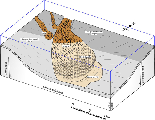 Fig. 7.—3D conceptual model of the Andatza coarse-grained turbidite system, with indication of the interpreted facies associations. Light-colored areas are interpretative since no outcrops of these areas exist. Fig. 7.—3D conceptual model of the Andatza coarse-grained turbidite system, with indication of the interpreted facies associations. Light-colored areas are interpretative since no outcrops of these areas exist.
|
|
The inner fan facies association changes laterally to the northwest and northeast into mudstones. This change occurs in a few decametres and indicates that the canyon was bound by muddy slopes both to the northwest and northeast. The lateral facies changes coincide with abrupt changes in the thickness of the studied units: the thickness of the inner part of the turbidite system is up to 550 m, whereas the muddy slopes show variable thicknesses between 75−400 m. To the northeast of the canyon these lateral changes in facies and thickness occur in a northwest-southeast direction and therefore, this direction is considered to be the westward continuation of the deduced trend of the Errekalde fault. This indicates the presence of a palaeohigh in that direction, where the finest sediments were deposited. The scarcity of coarse-grained resedimented deposits and the presence of sandy and silty turbidites suggest a low-gradient slope where occasional turbidity currents interrupted the overall low-energy conditions.
On the other hand, to the west and northwest of the canyon, the lateral facies and thickness changes allow interpreting these changes as the consequence of the latest Albian−early Cenomanian activity of the N−S-trending Zarate fault (Bodego & Agirrezabala, 2013) and the abundance of mudstones suggests the presence of another submarine muddy slope. However, the narrow and deep channels filled with disorganized conglomeratic sandstones are interpreted as gully channels (Fig. 7), since they are too small to be interpreted as canyons (e.g. Field et al., 1999; Surpless et al., 2009). These gullies would feed the turbidite system from other sources across high-gradient slopes. They are situated in the lower part of the system and erode the underlying mudstones of the Oztaran Fm (U1). Their stratigraphic position and the fact that gully fills change upward into mudstones indicate that the most erosive phase of the turbidite system occurred at the instauration of the system (latest Albian). Gullies are usually straight and dip parallel to the topographic dip (e.g. Mutti, 1977; Surlyk, 1987; Field et al., 1999; Surpless et al., 2009). Thus, this indicates that the slope environment had to be steep (Pickering et al., 1989) and dipping to the east (Cronin et al., 2005). Therefore, the basin would be bounded by two almost perpendicular muddy slopes with a canyon located along the intersection line and feeding a turbidite system downdip canyon.
The interpretation of the Andatza Fm as a deep-marine (turbidite) system differs from that of García-Mondéjar (1982), who interpreted these rocks as fluvial deposits. The present interpretation as a deep-marine system is in accordance with its stratigraphic location between an underlying shallow-marine interval (Rat, 1959; Campos, 1979; Bodego et al., 2015) and the overlying hemipelagic deposits (Feuillée, 1967; Mathey, 1987), in a broader scenario of an Aptian−Albian transgression during a main extensional phase.
Sediment dispersal pattern and tectonic controlTOP
The source area of the Andatza turbidite system was most probably located to the north/northwest of the LSB. This is based on the following facts: (1) the palaeocurrent analysis shows mainly southeastward palaeoflows; (2) proximal facies (conglomerates) are located in the northwestern corner of the LSB, limited by two submarine slopes; (3) the entry point is located at the intersection of the Zarate and Errekalde faults, whose synsedimentary activity is evidenced by the abrupt facies and thickness changes during the development of the turbidite system. The interplay between these faults created a highly subsident block between them which funneled the northerly sourced material. Canyon location at in the intersection of two basement fault families have been described in the literature in the Pyrenees (e.g. the Albian Mauvezin turbidite system; Souquet et al., 1985) and elsewhere (e.g. Prior & Doyle, 1985).
The deduced geometry of the system shows that the main canyon was confined between two almost perpendicular slopes controlled by the location of the footwalls of the Zarate and Errekalde faults. This would result in a main transport direction to the southeast drawing an “L”-type morphology for the turbidite system in plan-view. Due to the present-day erosion level, the middle and outer parts of the turbidite system, which would have existed further to the southeast of the study area, are not preserved. These interpreted palaeocurrent dispersal (L-shaped) schemes are usually controlled by tectonic structures in many basins (e.g. Californian Santa Cruz and San Pedro basins, Gorsline, 1978; Alborán basin, Cronin et al. 1995) and in the Albian of the BCB (Agirrezabala & García-Mondéjar, 1994). The structurally controlled expansion of turbidity currents is common in active and highly compartmentalized basins (Burke, 1967; Bachman & Graham, 1985; Agirrezabala & García-Mondéjar, 1994).
The facts that the base of the system is marked by an erosive unconformity (U1) and the stratigraphic position of the muddy-slope gullies is limited to the base of the system, suggest that a tectonic pulse caused the establishment of the system. This tectonic pulse would also coincide with the sedimentation of the Lasarte megabreccia toe-of-slope system (Bodego et al., 2008), during the latest Albian (dispar zone). Both, Lasarte and Andatza systems developed to the south of the Errekalde fault, indicating its synsedimentary activity during that time. This tectonic pulse observed in the LSB has also been identified in other regions of the BCB (e.g. García-Mondéjar et al., 1996) as well as in the central Pyrenean region (e.g. Choukroune, 1976; Debroas, 1978; Razin, 1989; Souquet and Peybernes, 1991; García-Senz, 2002). This suggests that the instauration of this depositional system records a regional tectonic pulse related to the Pyrenean-Bay of Biscay rift system.
Source of sedimentsTOP
Clast composition analysis indicates that most of the clasts resulted from the erosion of Palaeozoic−Triassic rocks (shales, quartzite, hydrothermal quartz, granule conglomerates and phyllites). Therefore, during the late Albian to early Cenomanian, an emergent Palaeozoic basement was being eroded to the north of the study area. This landmass would correspond to the Landes Massif (or “Biscay Hosch”; Voort, 1963; Agirrezabala & García-Mondéjar, 1994). Moreover, the size and shape of the gravels suggest short transport distances and the proximity of a source area supplying very coarse particles to a narrow marine shelf. Deep-water coarse-grained turbidite systems are rare in the geological record (Stow et al., 1996) and are usually connected to fan deltas or deltas through narrow siliciclastic shelves (e.g. Nemec & Steel, 1988; Stow et al., 1996). Coetaneous braid-plain deltas (Oiartzun Fm; Fernández-Carrasco et al., 1990b; Bodego et al., 2015) have been described a few kilometres westward from the study area, as part of the marginal infill of the LSB. Thus, it is reasonable to think that similar sedimentary systems fed the Andatza turbidite system from the north. In the Albian of the BCB, northerly sourced fan deltas (Monte Grande Fm.; Robles et al., 1988a,b) and coarse-grained turbidite systems (Ondarroa turbidite system; Agirrezabala & García-Mondéjar, 1994 ) have been described. The occurrence of distinct Albian coarse-grained turbidite systems along the northern margin of the BCB indicates that this basin margin had to be a very narrow margin during the Albian, with relatively short distances between the emerged source areas and the deep-water basins. Moreover, the Andatza turbidite system is similar in terms of processes and products to the contemporaneous Mendibeltza turbidite system of the Pyrenean realm (Souquet et al., 1985), where a narrow southern basin-margin area that fed the Pyrenean basin has been interpreted (Razin, 1989; Masini et al., 2014).
ConclusionsTOP
The depositional environment for the Andatza Fm has been reinterpreted based on facies analysis. It has been concluded that these deposits are of a deep-water character rather than fluvial to coastal. The depositional model of the system involves the sedimentation of coarse-grained (gravel) sediments by turbidite currents in deep erosive channels (canyon) and deposition of muds on adjacent slopes. Palaeocurrent analysis and facies distribution indicate the confined character of the canyon and the L-shaped geometry of the system due to the synsedimentary activity of the Zarate and Errekalde faults during the latest Albian−early Cenomanian. The deep-water system was fed with northerly derived sediments indicating the proximity of an emergent Palaeozoic source area.
ACKNOWLEDGEMENTSTOP
This research was funded by grant BFI05.398 from the Basque Government to A. Bodego. Funds were also supplied by Ministerio de Educación y Ciencia (MEC)−Ministerio de Ciencia e Innovación (MICCIN) (projects CGL2006−05491/BTE and CGL2009−08545), Euskal Herriko Unibertsitatea (UPV/EHU) (projects EHU06/62, UNESCO06/03 and EHUA15/18). LMA acknowledges financial support from the Eusko Jaurlaritza (Ikerketa Taldeak IT631-13 and IT930-16). The authors would like to acknowledge Luis Pedro Fernández and Idoia Rosales for critical comments and suggestions that significantly improved the original manuscript.
ReferencesTOP
| ○ |
Abreu, V.; Sullivan, M.; Pirmez, C. & Mohrig, D. (2003). Lateral accretion packages (LAPs): an important reservoir element in deep water sinuous channels. Marine and Petroleum Geology, 20: 631–648. https://doi.org/10.1016/j.marpetgeo.2003.08.003 |
| ○ |
Agirrezabala, L.M. & García-Mondéjar, J. (1994). A Coarse-Grained Turbidite System with Morphotectonic Control (Middle Albian, Ondarroa, Northern Iberia). Sedimentology, 41: 383–407. https://doi.org/10.1111/j.1365-3091.1994.tb02002.x |
| ○ |
Bachman, S.B. & Graham, S.A. (1985). La Jolla Fan, Pacific Ocean. In: Submarine Fans and Related Turbidite Systems (Bouma, A.H., Normark, W.R. & Barnes, N.E., Eds.), Springer-Verlag, New York, 65–70. https://doi.org/10.1007/978-1-4612-5114-9_11 |
| ○ |
Bodego, A.; Iriarte, E. & Agirrezabala, L.M. (2008). The deep-water Lasarte megabreccia (mid-Cretaceous, Basque-Cantabrian Basin): sedimentological evidences of a growth structure denudation. Geo-Temas, 10: 1201–1204.
|
| ○ |
Bodego, A. & Agirrezabala, L.M. (2013). Syn-depositional thin- and thick-skinned xtensional tectonics in the mid-Cretaceous Lasarte sub-basin, western Pyrenees. Basin Research, 25: 594–612. https://doi.org/10.1111/bre.12017 |
| ○ |
Bodego, A.; Iriarte, E.; Agirrezabala, L.M.; García-Mondéjar, J. & López-Horgue, M.A. (2015). Synextensional mid-Cretaceous stratigraphic architecture of the eastern Basque-Cantabrian basin margin (western Pyrenees). Cretaceous Research, 55: 229–261. https://doi.org/10.1016/j.cretres.2015.01.006 |
| ○ |
Burke, K. (1967). The Yallahs Basin: a sedimentary basin southeast of Kingston, Jamaica. Marine Geology, 5: 45–60. https://doi.org/10.1016/0025-3227(67)90067-9 |
| ○ |
Campos, J. (1979). Estudio geológico del Pirineo Vasco al W del río Bidasoa. Munibe, 31 (1-2): 3–319. |
| ○ |
Choukroune, P. (1976). Structure et évolution tectonique de la zone nord-pyrénéenne. Analyse de la déformation dans une portion de la chaîne à schistosité subvertical. Mémoire de la Societé Géologique de France, 127: 116.
|
| ○ |
Choukroune, P. & Mattauer, M. (1978). Tectonique des plaques et Pyrénées: sur le fonctionnement de la faille transformante nord-pyrénéenne; comparison avec des modèles actuels. Bulletin de la Societé Géologique de France, 20: 689–700.
|
| ○ |
Cronin, B.T.; Kenyon, N.H.; Woodside, J.; Den Bezemer, T.; Van der Wal, J.; Millington, A.; Ivanov, M.K. & Limonov, A. (1995). The Almeria Canyon: a meandering channel systema on an active margin, Alboran sea, western Mediterranean. In: Atlas of Deep Water Environments: Architectural Style in Turbidite Systems (Pickering, K.; Hiscott, R.; Kenyon, F.; Ricci Lucchi, F. & Smith, R.D.A., Eds.), Chapman & Hall, London, 84–88. https://doi.org/10.1007/978-94-011-1234-5_15 |
| ○ |
Cronin, B.T.; Celik, H.; Hurst A. & Turkmen, I. (2005). Mud prone entrenched deep-water slope channel complexes from the Eocene of eastern Turkey. Geological Society Special Publication, 244: 155–180.
|
| ○ |
Debroas, E.J. (1978). Évolution de la fosse du flysch ardoisier de l’Albien supérieur au Sénonien inférieur (zone interne métamorphique des Pyrénées navarro-languedociennes). Bulletin de la Societé géologique de France, v. 7: 639–648. https://doi.org/10.2113/gssgfbull.S7-XX.5.639 |
| ○ |
Denèle, Y.; Paquette, J.; Olivier, P. & Barbey, P. (2012). Permian granites in the Pyrenees: the Aya pluton (Basque Country). Terra Nova, 24: 105–113. https://doi.org/10.1111/j.1365-3121.2011.01043.x |
| ○ |
Fernández-Carrasco, J.; Cerezo, A.; Tijero, F.; Zapata-Sola, M.; Garrote, A.; García-Portero, J. & Muñoz, L. (1990a). Mapa geológico del País Vasco. 1:25000, Hoja de Zarautz 64-I, Ente Vasco de la Energía (EVE), Bilbao.
|
| ○ |
Fernández-Carrasco, J.; Cerezo, A.; Tijero, F.; Zapata-Sola, M.; Garrote, A.; García-Portero, J. & Muñoz, L. (1990b). Mapa geológico del País Vasco. 1:25000, Hoja de San Sebastián 64-II, Ente Vasco de la Energía (EVE), Bilbao.
|
| ○ |
Feuillée, P. (1967). Le Cénomanien des Pyrénées basques aux Asturies. Essai d’analyse stratigraphique. Mémoire de la Societé géologique de France, 46, 343 pp.
|
| ○ |
Field, M.; Gardner, J. & Prior, D. (1999). Geometry and significance of stacked gullies on the northern California slope. Marine Geology, 154: 271–286. https://doi.org/10.1016/S0025-3227(98)00118-2 |
| ○ |
García-Mondéjar, J. (1982). Aptiense-Albiense. In: El Cretácico de España (García, A., Ed.), Universidad Complutense, Madrid, 63–84.
|
| ○ |
García-Mondéjar, J.; Agirrezabala, L.M.; Aranburu, A.; Fernández-Mendiola, P.A.; Gómez-Pérez, I.; López-Horgue, M.A. & Rosales, I. (1996). Aptian-Albian tectonic pattern of the Basque-Cantabrian basin (northern Spain). Geological Journal, 31: 13–45. https://doi.org/10.1002/(SICI)1099-1034(199603)31:1<13::AID-GJ689>3.3.CO;2-P
|
| ○ |
García-Senz, J. (2002). Cuencas extensivas del Cretácico Inferior en los Pirineos centrales: Formación y subsecuente inversión. Tesis doctoral, Universidad de Barcelona, 310 pp.
|
| ○ |
Gorsline, D.S. (1978). Anatomy of margin basins. Journal of Sedimentary Petrology, 48: 1055–1068. https://doi.org/10.1306/212F75F4-2B24-11D7-8648000102C1865D |
| ○ |
Haq, B.U. (1988). Fluctuating Mesozoic and Cenozoic Sea Levels and Implications for Stratigraphy. American Association of Petroleum Geologists Bulletin, 72: 1521–1521.
|
| ○ |
Lowe, D.R. (1982). Sediment gravity flows: II. Depositional models with special reference to the deposits of high-density turbidity currents. Journal of Sedimentary Petrology, 52 (I): 279–297.
|
| ○ |
Masini, E.; Manatschal, G.; Tugend, J.; Mohn, G. & Flament, J.-M. (2014). The tectono-sedimentary evolution of a hyper-extended rift basin: the example of the Arzacq-Mauléon rift system (Western Pyrenees, SW France). International Journal of Earth Sciences (Geologische Rundschau), 103: 1569–1596. https://doi.org/10.1007/s00531-014-1023-8 |
| ○ |
Mathey, B. (1987). Les flyschs cretacé supérieur des Pyrénées basques: age, anatomie, origine du matériel milieu de dépot et relations avec l’ouvert du Golfe de Gascogne. Mémoire Géologique de la Université de Dijon, 12, 402 pp.
|
| ○ |
Montadert, L.; Roberts, D.G.; de Charpal, O. & Guennoc, P. (1979). Rifting and subsidence of the northern continental margin of the Bay of Biscay. In: Initial Reports of the Deep Sea Drilling Project, Leg 48, Brest, France to Aberdeen, Scotland, 1976 (Scripps Institution of Oceanography, Ed.). UK distributors IPOD Committee, NERC, Swindon, 1025–1060. https://doi.org/10.2973/dsdp.proc.48.154.1979 |
| ○ |
Mutti, E. (1977). Distinctive thin-bedded turbidite facies and related depositional environments in the Eocene Hecho Group (South-Central Pyrenees, Spain). Sedimentology, 24: 107–131. https://doi.org/10.1111/j.1365-3091.1977.tb00122.x |
| ○ |
Mutti, E. (1992). Turbidite Sandstones. Agip-Istituto di Geologia. Università di Parma, 275 pp. |
| ○ |
Mutti, E. & Ricci Lucchi, F. (1972). Turbidites of the Northern Apennines: Introduction to facies analysis (English translation by T.H. Nilsen, 1978). International Geological Review, 20: 125–166. https://doi.org/10.1080/00206817809471524 |
| ○ |
Mutti, E. & Ricci Lucchi, F. (1975). Turbidite facies and facies associations. In: examples of turbidite facies and facies associations from selected formations of the northern Apennines. IX Int. Congr. Sedm. Nice-75, Field Trip A. 11.
|
| ○ |
Nemec, W. & Steel, R.J. (Eds.) (1988). Fan Deltas: Sedimentology and Tectonic Settings, Blackie, London, 444 pp. |
| ○ |
Normark, W.R. (1970). Growth patterns of deep-sea fans. American Association of Petroleum Geologists Bulletin, 54: 2170–2195. |
| ○ |
Pesquera, A. & Pons, J. (1990). The Aya Pluton (Spanish Basque Pyrenees) - Structural Pattern, Ascent Model and Regional Tectonic Implication. Bulletin de la Societé Geologique de France, 6: 13–21. https://doi.org/10.2113/gssgfbull.VI.1.13 |
| ○ |
Pickering, K.; Stow, D.; Watson, M. & Hiscott, R. (1986). Deep-water facies, processes and models: a review and classification scheme for modern and ancient sediments. Earth-Science Reviews, 23: 75–174. https://doi.org/10.1016/0012-8252(86)90001-2 |
| ○ |
Pickering, K.; Hiscott, R. & Hein, F.J. (1989). Deep Marine Environments: Clastic Sedimentation and Tectonics, Unwyn Hyman, London, UK, 416 pp.
|
| ○ |
Prior, D.B. & Doyle, E.H. (1985). Intra-slope canyon morphology and its modification by rockfall processes, US Atlantic continental-margin. Marine Geology, 67: 177–196. https://doi.org/10.1016/0025-3227(85)90155-0 |
| ○ |
Rat, P. (1959). Les pays crétacés basco-cantabriques (Espagne).Thèse publié, Université de Dijon, 18, 525 pp. |
| ○ |
Razin, P. (1989). Évolution tecto-sédimentaire alpine des Pyrénées Basques a l’ouest de la transformante de Pamplona (Province du Labourd). Tesis doctoral, Université de Bordeaux III, 464 pp.
|
| ○ |
Robles, S.; García-Mondéjar, J. & Pujalte, V. (1988a). A retreating fan-delta system in the Albian of Biscay, northern Spain: facies analysis and palaeotectonic implications. In: Fan Deltas: Sedimentology and Tectonic Settings (Nemec, W. & Steel, R.J., Eds.), Blackie, Glasgow, 187–211.
|
| ○ |
Robles, S.; Pujalte, V. & García-Mondéjar, J. (1988b). Evolución de los sistemas sedimentarios del margen continental cantábrico durante el Albiense y Cenomaniense, en la transversal del litoral vizcaíno. Revista de la Sociedad Geológica de España, 1: 409–441.
|
| ○ |
Robles, S.; Quesada, S.; Rosales, I.; Aurell, M. & García-Ramos, J.C. (2004). El Jurásico marino de la Cordillera Cantábrica. In: Geología De España (Vera, J.A., Ed.), Sociedad Geológica de España-Instituto Geológico y Minero de España (IGME), Madrid, 279–285.
|
| ○ |
Roca, E.; Muñoz, J. A.; Ferrer, O. & Ellouz, N. (2011). The role of the Bay of Biscay Mesozoic extensional structure in the configuration of the Pyrenean orogen: Constraints from the MARCONI deep seismic reflection survey. Tectonics, 30: TC2001.
https://doi.org/10.1029/2010TC002735 |
| ○ |
Soler y José, R. (1972). El Jurásico y Cretáceo inferior de Leiza y Tolosa (Cuenca Cantábrica Oriental). Boletín Geológico y Minero, 83(6): 582–594.
|
| ○ |
Souquet, P.; Debroas, E.J.; Boirie, J.; Pons, P.; Dixari, G.; Roux, J.; Dol, J.; Thieuloy, J.; Bonnemaison, M.; Manivit, H. & Peybernès, B. (1985). Le Group du Flysch Noir (Albo-Cénomanien) dans Les Pyrénées. Bulletin Centre Recherche Pau-SNPA, 15: 183–252.
|
| ○ |
Souquet, P. & Peybernès, B. (1991). Stratigraphie séquentielle du cycle Albien dans les Pyrénées Franco-Espagnoles. Bulletin Centre Recherche Pau-SNPA, 15: 195–213.
|
| ○ |
Stow, D.; Reading, H.G. & Collinson, J.D. (1996). Deep seas. In: Sedimentary Environments: Processes, Facies and Stratigraphy, 3rd ed. (Reading, E., Ed.), Blackwell Science, Oxford, 395–453.
|
| ○ |
Surlyk, F. (1987). Slope and deep shelf gully sandstones, Upper Jurassic, East Greenland. American Association of Petroleum Geologists Bulletin, 71: 464–475.
|
| ○ |
Surpless, K.D.; Ward, R.B. & Graham, S.A. (2009). Evolution and stratigraphic architecture of marine slope gully complexes: Monterey Formation (Miocene), Gaviota Beach, California. Marine Petroleum Geology, 26: 269–288. https://doi.org/10.1016/j.marpetgeo.2007.10.005 |
| ○ |
Voort, H.B. (1963). Zum flysch problem in den Westpyrenäen. Geologie Rundschau, 53: 220–233. https://doi.org/10.1007/BF02040748 |
| ○ |
Walker, R.G. (1978). Deep water sandstone facies and ancient submarine fans: models for exploration for stratigraphic traps. American Association of Petroleum Geologists Bulletin, 62: 932–966.
|