Structure of the Alpujarride Complex and hydrogeological observations to the NW of Sierra Tejeda (Granada and Malaga provinces, Betic Internal Zone, Spain)
Estructura del Complejo Alpujárride y observaciones hidrogeológicas al NO de Sierra Tejeda (provincias de Granada y Málaga, Zona Interna Bética
C. Sanz de Galdeano1, J. Prieto-Mera2, B. Andreo2
1Instituto Andaluz de Ciencias de la Tierra (IACT) (CSIC- Univ. Granada). Fac. Ciencias, Granada. España. Email: csanz@ugr.es. ORCID ID: https://orcid.org/0000-0002-3256-7648
2Centre of Hydrogeology (CEHIUMA) and Department of Geology of the University of Málaga. Edificio I+D Ada Byron. C/Arquitecto Francisco de Peñalosa 18. 29071, Málaga (Spain). ORCID ID: https://orcid.org/0000-0002-2600-1568, https://orcid.org/0000-0002-3769-7329
| |
ABSTRACT
In the NW of Sierra Tejeda (Spain) it is possible differentiate only two Alpujarride tectonic units, i.e. the Almijara and, in an upper position, the Robledal unit, simplifying previous divisions. Hydrogeological data support this interpretation since a hydraulic connection exists between the two areas occupied by marbles (Sierra Tejeda and Rodaderos sectors). Both areas has been previously considered as belonging to two different tectonic units not directly connected. In the Robledal unit, gneisses in the lower part of the lithologic sequence correlate with other units of the Guájares-Jubrique/Los Reales group (upper group of Alpujarride units). Extensional deformations are superposed over these tectonic units, but, according to field observations, they have not the enormous importance attributed to them in previous models, as they do not differentiate new tectonic units, at least in this area. New E-W faults are drawn along the northern edge of Sierra Tejeda, contributing to the westward drift of the Betic Internal Zone.
Keywords: Alpujarride complex; Betic Internal Zone; E-W faults; extensional deformations.
|
| |
RESUMEN
Al NO de Sierra Tejeda solo se pueden diferenciar dos unidades tectónicas alpujárrides, la de Almijara y, sobre ella, la de Robledal, simplificando divisiones previas.
Datos hidrogeológicos avalan esta interpretación ya que apuntan a la posible conexión hidráulica entre dos áreas ocupadas por mármoles (sectores de Tejeda y Rodaderos) que previamente han sido consideradas como unidades tectónicas diferentes lo que lo hace improbable. En la unidad Robledal la presencia de gneises en la parte inferior de la secuencia litológica permite su correlación con otras unidades del grupo Guájares-Jubrique/Los Reales (grupo superior de unidades del Complejo Alpujárride). Deformaciones extensionales se superponen al cabalgamiento de unidades, pero a las que no damos la enorme importancia atribuida en previos modelos, pues no permiten, al menos en esta área, la diferenciación de nuevas unidades tectónicas. Se muestran, además, nuevas fallas E-O situadas al N de Sierra Tejeda, que facilitaron el desplazamiento hacia el oeste de la Zona Interna Bética.
Palabras clave: Complejo Alpujárride; deformaciones extensionales; fallas E-O; Zona Interna Bética.
|
Introduction TOP
The structure of the Alpujarride Complex and its division into tectonic units is a subject of continuous updates and scientific debates. Several authors over recent decades have worked on the division of the tectonic units in the Alpujarride Complex of the Internal Zone of the Betic Cordillera (Elorza et al. 1978; Simancas and Campos, 1993; Sanz de Galdeano, 1997; Alonso-Chaves & Orozco, 2007; etc.). The division proposed in each case depends not only on the geological data gathered through fieldwork but also on the tectonic model that had been applied by each author. In some cases, these models lead to inaccurate interpretations. In this sense, studies in related sciences such as hydrogeology may reach conclusions or interpretations that are not compatible with some of the preexisting geological premises in the study area. Also, an accurate control of the stratigraphic sequences is necessary to avoid, how it can be observed, the multiplication of tectonic units, something now signaled in several sectors of the Betic Cordillera (Martín-Martín et al., 2006; Sanz de Galdeano & López Garrido, 2003; Sanz de Galdeano, 2017).
In the northern area of Sierra Tejeda (S Spain), different aspects are discussed regarding the possible contradictions raised by the previous interpretations of units, in some cases separating continuous lithological sequences or, on the contrary, joining different lithological sequences at present separated by tectonic contacts, based on proposals that are incompatible with hydrogeological field data and observations. Consequently, the aim of this work is to propose a differentiation of tectonic units in the study area consistent with several geological data, including those of hydrogeological and stratigraphic features. To achieve this purpose the successions of deformations affecting the area are also described, integrating them in a wider regional frame. Moreover, the carbonate sequence to the N of Alcaucín is presented, something not done so far. In the description made, the study area was divided into two separate sectors: Alcaicería and Majadas. The former, the main sector, is located in the south of Alhama de Granada (Figs.1 and 2), and the latter is situated W of the first one, to the N of Alcaucín and S of Zafarraya (Figs.1 and 3).
|
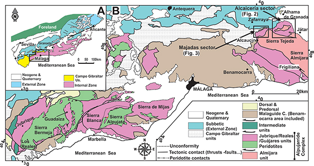 Fig. 1.—General regional setting. A: Geologic sketch map of the Betic Cordillera. The position of B is marked. B: Main geologic features of the western part of the Betic Internal Zone. The position of Figs. 2 (Alcaicería sector) and 3 (Majadas sector) is marked in the NE part of the figure. Fig. 1.—General regional setting. A: Geologic sketch map of the Betic Cordillera. The position of B is marked. B: Main geologic features of the western part of the Betic Internal Zone. The position of Figs. 2 (Alcaicería sector) and 3 (Majadas sector) is marked in the NE part of the figure.
|
|
|
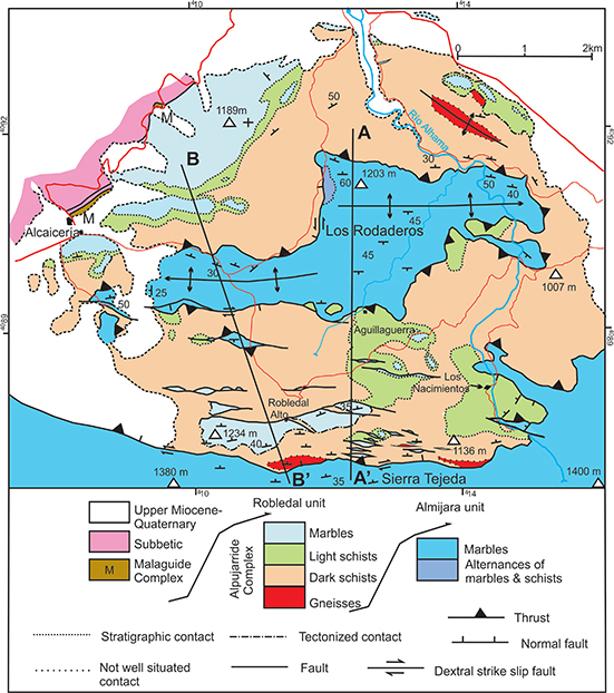 Fig. 2.—Geological map of the Alcaicería sector. Its position is marked in Fig. 1. Fig. 2.—Geological map of the Alcaicería sector. Its position is marked in Fig. 1.
|
|
|
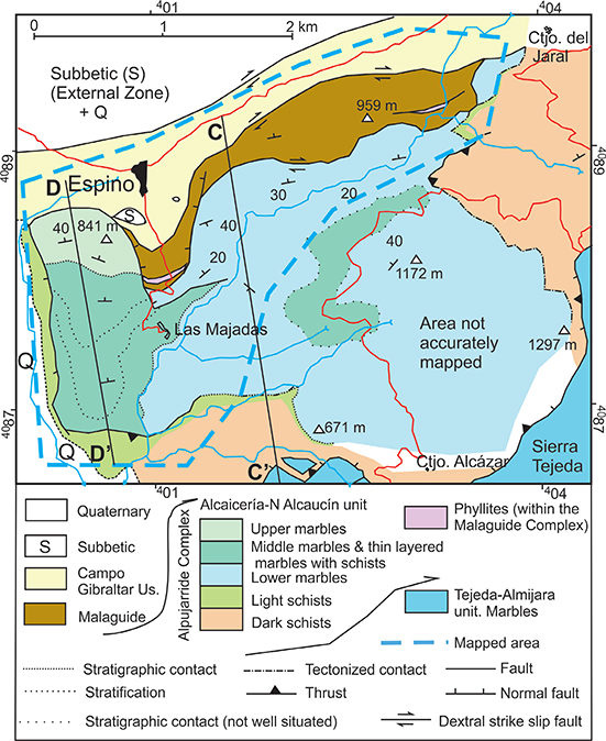 Fig. 3.—Geological map of the N of the Majadas sector. Its position is marked in Fig. 1. Fig. 3.—Geological map of the N of the Majadas sector. Its position is marked in Fig. 1.
|
|
Geological setting and backgroundTOP
SettingTOP
The study area is situated to the NW of Sierra Tejeda, in the Granada and Malaga provinces (southern Spain). Geologically, it belongs to the Internal Zone of the Betic Cordillera, which is formed by three superposed complexes (in ascending order): Nevado-Filabride, Alpujarride (where the study area is mainly located) and Malaguide (Fig.1).
The Alpujarride Complex can be divided into three main groups of superposed tectonic units, formed by Paleozoic and Triassic metapelitic rocks and Triassic marbles (Aldaya et al., 1979). The Malaguide Complex, in this area, is composed of Carboniferous lutites and graywackes, as well as Triassic red clays, sandstones, and conglomerates.
Part of the study area is situated over the tectonic contact between the Betic Internal and External Zones. The latter includes the Subbetic, formed by Mesozoic and Tertiary sedimentary rocks. Moreover, in some places the Campo de Gibraltar units, formed mainly by Tertiary clays and sandstones, are tectonically situated in between the Subbetic and the Internal Zone. These tectonic relations between the Internal and External Zones resulted from a major dextral strike-slip transcurrence, superposed over previous nappe structures (Crespo-Blanc, 2008; Sanz de Galdeano, 2012b).
BackgroundTOP
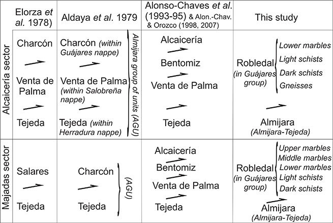
In the sector of Alcaicería, Elorza et al. (1978) defined (from bottom to top) the Tejeda, Venta de la Palma, and Charcón tectonic units. More to the W, in the Majadas sector, these authors distinguished the same Tejeda unit and that of Salares, situated in an upper position. Aldaya et al. (1979) proposed similar differentiation, although in the Majadas sector these latter authors do not use the name of Salares unit, and maintain that of Charcón unit (Table 1).
Table 1.—Different proposals of divisions in tectonic units in the study area. In the column of the present study are indicated the different lithologic formations existing in the area.
|
In several studies, Alonso-Chaves et al. (1993 and 1995 a & b) and Alonso-Chaves & Orozco (1998 and 2007), in the Alcaicería and Majadas sectors, established different tectonic units, from bottom to top: the Tejeda, Venta de Palma, Bentomiz, and Alcaicería, all separated by low-angle extensional faults (Table 1).
Simancas and Campos (1993) followed the differentiation of Elorza et al. (1978) although using the name of Sayalonga tectonic unit (an urban settlement in the SW of Sierra Tejeda) instead the Charcón unit, for the upper unit. Azañón & Crespo-Blanc (2000) described a wide area of the Alpujarride Complex, and, although they did not describe in detail the areas now under study, their unit division resembles that of Elorza et al. (1978), emphasizing the importance of the low-angle normal faults that separate the units.
Sanz de Galdeano & López-Garrido (2003) proposed a simplification of the number and names of the units existing in this central part of the Alpujarride Complex, differentiating only the Almijara tectonic unit (or Almijara-Tejeda unit) and, above it, the Guájares group of units.
Stratigraphy of the tectonic unitsTOP
According to the field observations, in both studied sectors, only two tectonic units could be identified, i.e. Almijara and Guájares. The name of the Guájares unit actually refers to a group of units all with similar tectonic and lithologic character, which –without disregarding their relations—can be called differently in each area. In the present work, it will be named as Robledal unit (Table 1), referring to several farmhouses of this area and seeking to avoid confusion with that of Alcaicería used by Alonso-Chaves et al. (1993) or by Alonso-Chaves & Orozco (2007) to denominate a subdivision of the Charcón unit of Elorza et al. (1978).
The Almijara unitTOP
The lithological sequence of this unit, which has been described by Sanz de Galdeano & López-Garrido (2003), can be seen in a simplified form in Figure 4. In this sequence, several aspects stand out:
|
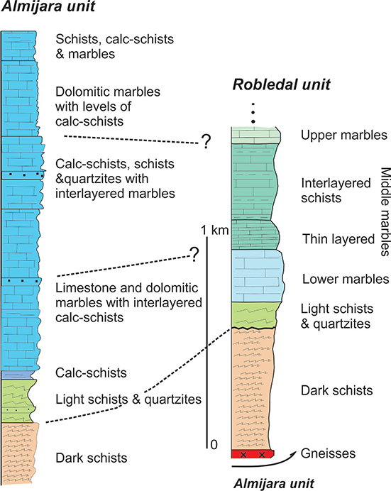 Fig. 4.—Stratigraphic cadre. The column on the left is simplified from Sanz de Galdeano & López-Garrido (2003). In the column of the Robledal unit are represented the different formations of marbles visible in the N of Alcaucín area. Fig. 4.—Stratigraphic cadre. The column on the left is simplified from Sanz de Galdeano & López-Garrido (2003). In the column of the Robledal unit are represented the different formations of marbles visible in the N of Alcaucín area.
|
|
The lower visible rocks of its sequence are dark schists and in this unit, it had not been seen gneisses. The transition from the schists to marbles is progressive, alternating in this passage the two types of rocks, a characteristic frequently found in other Alpujarride units.
The calcareous part of the sequence (Triassic marbles) is not homogeneous and presents differentiated formations. The preserved thickness of these marbles can reach up to 1650 m.
In the present study, the marbles of this unit have not been described, because this is not the main aim, but their distribution and structure can be seen in Sanz de Galdeano (1989).
The Robledal unit TOP
The lower terms of the lithological sequence of this unit are composed of gneisses (Fig. 4), showing different facies, from layers containing feldspar crystals reaching several cm in size to others only slightly differentiated from dark schists. The maximum thickness observed can reach up to 100 m, although the bottom part has not been possible to recognize it in the field observations. These gneisses, cited by Elorza et al. (1978), are situated over the Almijara unit on the northern edge of Sierra Tejeda, there cropping out along several kilometers (Fig. 2). Also, other gneisses crop out (Alonso-Chaves et al., 1995a), in some northern areas of Alcaicería sector (Fig. 2).
Above the gneisses, crop out the Dark schists Fm, generally attributed to the Paleozoic, with more than 400-500 m of thickness. Its rocks contain garnet, sillimanite, and andalusite. In some places these schists are extremely micaceous, giving rise to a friable rock.
Overlying the dark schists, presumably separated by an unconformable contact, there is the Light schists Fm, in many cases with quartzites. It is generally attributed to the Triassic. The maximum observed thickness is on the order of 200 m.
The contact with the marbles situated above is transitional but rapid. In this transition, some layers of calc-schist and marbles begin to be interbedded with the schists, but the marbles predominate in a few meters.
In the area of Alcaicería, the marbles cropping out correspond to a lower formation of limestone marbles with a thickness of some 200-300 m. However, in the Majadas sector, two more formations are present (Figs. 3, 4, 5C & D, & 6A): overlying the aforementioned lower formation appear other marbles (informally can be named as Middle marbles Fm) with thinner layers, locally with marly intercalations (this new formation could be divided into two). This is overlain by other marbles (provisionally named Upper marbles Fm), which in many cases form layers that present interlayered clear, greenish schists and light quartzites (the number of formations that can be distinguished in reality depends on the detail of the description). The total thickness of the marbles preserved in the Majadas sector is around 700 m and the top of it is not conserved.
|
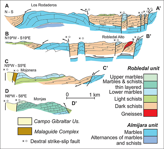 Fig. 5.—Geological cross-sections of the sectors of Alcaicería (A & B) and Majadas (C & D). Their positions are indicated in Fig. 2. Fig. 5.—Geological cross-sections of the sectors of Alcaicería (A & B) and Majadas (C & D). Their positions are indicated in Fig. 2.
|
|
|
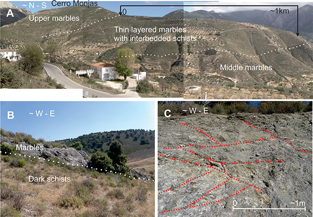 Fig. 6.—Photos of the area studied. A: partial view of the marble formations visible to the N of Alcaucín. Until now, all these formations were considered as an undifferentiated whole. B: fault scarp separating the marbles of Rodaderos (Almijara unit) from the dark schists of the Robledal unit. In this contact, different layers of marbles are in contact with the schists. Its situation corresponds to the SW part of Rodaderos. C: partial view of the extensional deformations affecting the light schists in an area situated to the NE of Rodaderos. Only several lines of faults have been marked. The character of these structures is fragile. Fig. 6.—Photos of the area studied. A: partial view of the marble formations visible to the N of Alcaucín. Until now, all these formations were considered as an undifferentiated whole. B: fault scarp separating the marbles of Rodaderos (Almijara unit) from the dark schists of the Robledal unit. In this contact, different layers of marbles are in contact with the schists. Its situation corresponds to the SW part of Rodaderos. C: partial view of the extensional deformations affecting the light schists in an area situated to the NE of Rodaderos. Only several lines of faults have been marked. The character of these structures is fragile.
|
|
StructureTOP
The Alcaicería sectorTOP
Figure 2 and the geological cross-sections (A and B) of Figure 5 show the structure of the Alcaicería sector. These cross-sections present the main characteristics of the structure: the thrust of the Robledal unit over the Almijara unit, the presence of roughly E-W folds (mainly that of Rodaderos) and the existence of many E-W strike-slip faults situated between Rodaderos and Sierra Tejeda.
The fold of Rodaderos is an anticline which affects the thrust contact of the tectonic units Almijara and Robledal. In some places, its northern edge dips approximately 60º to the N, while the south edge generally dips about 30º southwards. This latter edge is affected by a fault, sinking and also laterally displacing it (Fig. 6B). On the whole, the fold is like an E-W half cylinder, but its width changes radically, as can be seen in Figure 2. This change is facilitated by a nearby N-S fault which sinks the western edge and moves as a sinistral and normal strike-slip fault.
The above-mentioned E-W strike-slip faults are easily visible in the places where they separate different lithologies. On the contrary, when they are situated within a given lithology, for example, within dark schists, the faults cannot be followed. Therefore these faults are presented in Figure 2 as discontinuous lines.
The surface of each fault rarely shows visible minor structures, due to the soil layers and vegetation. Only in the fault situated to the SW of the Rodaderos striae and other minor features have been observed, indicating dextral to normal-dextral displacements.
Another aspect to take into account is the existence of extensional deformations, observable, among other places, in the northern part of the sector (Fig. 6C). The extension in this area has roughly an E-W direction. These deformations are not limited to the contact between different types of rocks, but in some cases can affect a large part of the lithologic sequence, for instance, locally affecting the entire thickness of the light schist. On the contrary, in other places, these extensional deformations are not visible at all, and the contact between different types of rock are not tectonically affected, preserving the original stratigraphic sequences, invalidating any interpretation involving a tectonic separation into units.
The Majadas sector TOP
The northern part of this sector (Fig. 3) was more studied than the central area of it, since it lacks reliable mapping to separate the light schist from the marbles and to show the different marble formations.
The thrust of the Robledal unit over the Almijara unit can be observed, although in several parts near Alcaucín this superposition has been strongly affected by normal-sinistral faults sinking its NW blocks, where the Robledal unit is preserved.
The marble formations previously described in the stratigraphic section can be seen in the northern part of this sector (Fig. 5 C&D, Fig. 6A), although, as indicated, exist not only there.
In this sector of Majadas, the contact between the Malaguide and the Alpujarride complexes is nearly vertical, generally strongly dipping to the north. The same occurs with the contact of the Malaguide Complex and the Campo de Gibraltar units and between these units and the Subbetic (Sanz de Galdeano, 2012a).
Within the Malaguide complex, there is an unexpected structure clearly visible at certain points where new roads cut the rocks. At those points, a large intercalation of phyllites is situated in between the Carboniferous lutites (these phyllites can be seen in two narrow areas in Fig. 3). These rocks can be attributable to the Alpujarride Complex and present tectonic contacts with the surrounding rocks, and their thickness varies, in some places reaching up to 20 m.
Hydrogeological dataTOP
The marbles of the Sierra Tejeda constitute an aquifer whose northern limit is formed by the contact with metapelitic rocks of low permeability (of the Robledal unit). According to the previous geological works, the outcrop of marbles of Rodaderos had never been considered specifically as part of the Sierra Tejeda aquifer, since it was considered to have an upper tectonic position, and therefore hydraulic connection was deemed unlikely. The first reference about the Rodaderos aquifer, from hydrogeological point of view, was carried out by ITGE-DG (1990) as part of the hydrogeological atlas of the Granada province, where they define it as a small independent aquifer since they did not evaluate its water resources (2 hm3/year) jointly with the aquifer of Sierra Tejeda. In the other hand, the study of the origin of the waters drained by a thermal spring (Baños de Alhama), located at north to the study area, reveal that the most probable recharge area of this outlet must be Sierra Tejeda aquifer because the isotopic δ18O value (-8.58‰) imply a high altitude of recharge (López-Chicano, 1992; López-Chicano and Pulido-Bosch, 1996). In these works, the tectonic position of the Rodaderos aquifer is not addressed directly, but the conclusions suggest the existence of an underground flow from Sierra Tejeda to the north through the marbles of Rodaderos.
The water table has been measured at a well (1040 m a.s.l) in Sierra Tejeda (S. Tejeda in Fig.7) and at four points in Rodaderos area (Fig. 7): a quarry (1012 m a.s.l), Parrillas well (1005 m a.s.l), Rodaderos well (999 m a.s.l), and Rodaderos spring (951 m a.s.l). The water table elevations observed at the study site progressively decrease from Sierra Tejeda to Alhama River. The major groundwater flow path in the Rodaderos sector goes predominantly towards the NE, reaching the main karst outlets to 945 m a.s.l (Alhama River; Fig.7). The Parrillas well (Fig. 7) is exploited for water supply agricultural irrigation, but in the same location has been documented a sporadic spring active during high waters periods (ITGE-DG 1990; López-Chicano, 1992) and flowing toward the polje of Zafarraya (NO Rodaderos). The occasional functioning of this outlet as a consequence of the piezometric level rise, in response to significant pluviometric episodes, seems to indicate that this groundwater source is a trop-plein or overflow spring.
|
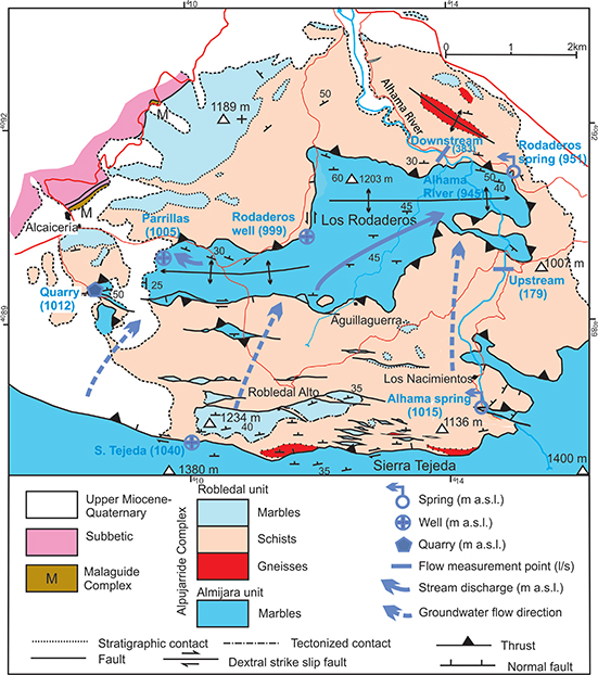 Fig. 7.—Hydrogeological sketch. Water table levels and main deduced groundwater flow path. Fig. 7.—Hydrogeological sketch. Water table levels and main deduced groundwater flow path.
|
|
The groundwater drained by Alhama River, the source of which is in Los Nacimientos sector in Sierra Tejeda aquifer (Alhama spring; Fig.7), was measured upstream (Q=179 l/s as average value) and downstream (Q=383 l/s) of the calcareous outcrop of Rodaderos in several flow-measurement campaigns (Tab. 2). During the execution of these hydrodynamic records, no significant water runoff was detected through tributary streams, which does not mean that in high waters it may be not exist. Table 2 shows that the Alhama River increases the flow more of 200 l/s (114% more) as it passes through Rodaderos outcrop.
Table 2.—Discharge results of the flow-measurements campaigns upstream and downstream of the Alhama River in 2017
| Date |
Upstream (l/s) |
Downstream (l/s) |
Flow increase (l/s) |
Flow increase (%) |
| 30/01/2017 |
135 |
329 |
194 |
145 |
| 15/02/2017 |
142 |
395 |
253 |
178 |
| 16/03/2017 |
252 |
477 |
225 |
89 |
| 10/04/2017 |
247 |
490 |
243 |
99 |
| 11/05/2017 |
210 |
449 |
240 |
115 |
| 08/06/2017 |
179 |
341 |
162 |
90 |
| 06/07/2017 |
156 |
328 |
172 |
111 |
| 20/09/2017 |
115 |
256 |
141 |
123 |
| Mean |
179 |
383 |
204 |
114 |
The marbles of Rodaderos occupy an area of 7.74 km2 and annual rainfall for the 2016/2017 water year was 682 mm. If we take into account an efficient infiltration of 42% calculated with the APLIS method (Andreo et al. 2018) for the marbles of Sierra Almijara (SE of the study area) in the same tectonic unit, the average resources of the Rodaderos aquifer are 2.21 hm3/year, similar to the value obtained by ITGE-DG (1990).
Rodaderos aquifer would require an effective infiltration of 6.4 hm3/year to justify an average discharge of 204 l/s (Table 2), without taking into account the resources extracted for irrigation. In a preliminary interpretation, the source of the increase of flow in the Alhama River cannot come only from with the recharge occurring directly on Rodaderos marbles, because this area is too small to account for this. Additionally, from the isotopic point of view, the average values of δ18O of the water drained by Rodaderos (-8.41 ‰) and Alhama (-8.30 ‰) springs were similar to those obtained by López-Chicano and Pulido-Bosch (1996) in Baños de Alhama spring, where estimated a recharge height above of 1500 m a.s.l. The elevation of Rodaderos outcrop (1203 m a.s.l) seems to be insufficient if we assume that the height of recharge of the groundwaters that drains is similar to the obtained in the study of López-Chicano and Pulido-Bosch (1996), which would be consistent with the hypothesis of the existence of the hydraulic connection between Rodaderos and Sierra Tejeda aquifers.
DiscussionTOP
The Robledal tectonic unit thrusts the marbles of Rodaderos with a contact visible on both sides, N and S, of this relief. The surface of this contact coalesces laterally, something particularly visible to the E (Fig. 2). This structure indicates that only a single unit thrusts the marbles of Rodaderos and that a division into two or three tectonic units has no justification. This thrust surface is affected in some places by later faults, as can be seen in the southern part of the cross-section B of Figure 5.
The relationship between the dark and light schists of the Robledal unit is well preserved in some places, indicating a former stratigraphic contact, as occurs to the SE of Rodaderos, while in other places this relation has been tectonically affected. This last feature occurs N of Rodaderos where a large part of the lithological sequence underwent a clear extension, or near the farmhouse of Robledal Alto, where the light schists have been practically laminated, putting the dark schists and the marbles of this unit close together (Fig. 2).
On the southern edge of the Rodaderos anticline, particularly in its SW part, the contact between the marbles of Rodaderos and the dark schists was interpreted by Elorza et al. (1978) and Alonso-Chaves & Orozco (2007, among others, as a stratigraphic contact. However, the dark schists are situated generally over the marbles, this being clearly visible in many places where different levels of marbles (not a single layer) are under the dark schists and, moreover, part of this contact is affected by a more recent E-W fault (Fig. 6B), whose surface is well exposed and presents minor structures, corresponding to dextral and normal dextral displacement.
The previous division into tectonic units had a key point in this contact. If the contact between the marbles of Rodaderos and the dark schist were a single stratigraphic contact, then these marbles and the dark schists would form the Venta de la Palma unit of Elorza et al. (1978). However, this continuity is contradicted by the features described in the preceding paragraph. A major tectonic contact is present, changing the previous interpretation—that is, the Venta de la Palma unit does not exist as defined, and furthermore the dark schists, with the gneisses at the bottom, and the light schists and other marbles above (forming the Robledal unit), must be separated from the Rodaderos marbles.
This new interpretation agrees with the preliminary hydrogeological data shown. The spatial distribution of groundwater levels and the increasing discharge (around 100%) of Alhama River through the Rodaderos carbonate outcrop suggest the hydrogeological connection with Sierra Tejeda aquifer. Rodaderos outcrop is too small to be responsible for the increasing discharge of Alhama River. Therefore, the tectonic and the hydrogeological data clearly point to the connection of the marbles of Rodaderos with those of Almijara unit. According to these hydrogeological data and their interpretation, the marbles of Sierra Tejeda and Rodaderos outcrop would constitute the same aquifer, so that they must be geologically located in the same tectonic unit.
The extensional structures previously described by Alonso-Chaves & Orozco (2007, among other articles) were interpreted as contacts separating tectonic units (Venta de Palma, Bentomiz and Alcaicería). However, these deformations, of fragile character in the study area, affect the former continuous lithologic sequence, without changing its original order—that is, there are extensional deformations but this does not necessarily means the formation of new tectonic contacts separating new units.
In the southern sector of the Alcaicería area, north of Sierra Tejeda, Alonso-Chaves & Orozco (2007) indicated the existence of more extensional structures in places corresponding to E-W faults in which minor structures cannot be seen or there is no tectonic contacts. Moreover, these authors assigned lower and middle Miocene ages to these structures, although this area lacks any sediments of these ages. Apparently, the authors followed the age attribution of extensional structures in other places of the Cordillera and applied them to the area of the NW of Sierra Tejeda. These types of interpretations correspond to the application of previous models, but in the study area, it is not possible to maintain these age attributions.
The E-W faults correspond to the system of E-W dextral strike-slip faults affecting the Betic Internal Zone (Sanz de Galdeano et al., 1985; Sanz de Galdeano, 1989, 1990, 2008). According to the interpretation of Sanz de Galdeano (1989), a major fault lies N of Sierra Tejeda, but the new data show that this, in fact, corresponds to a wide fault zone. This interpretation is applicable not only to the Alcaicería sector but also to the northern border of the Majadas sector, where the contact between the Alpujarride and Malaguide complexes as well as with the Campo de Gibraltar units and the Subbetic leads to the same conclusion.
The Majadas sector preserves a large part of the formations of marbles of the Robledal unit. In the NW of Sierra Tejeda, a local depressed area was formed owing to the coincidence in this sector of the aforementioned E-W faults, the normal sinistral faults also cited previously, and the NW end of the Frigiliana fault (Sanz de Galdeano, 1989).
In what concerns to the elongated body of phyllites situated within the Malaguide Carboniferous rocks, for its present position cannot correspond to the Robledal unit or other lower Alpujarride units. Its origin is to be found in some of the Casares-Federico units (Didon et al., 1973), also called Imbrications of Benarrabá (Balanyá, 1991) and Intermediate units (Sanz de Galdeano et al., 2001). This may be because during the double process of the thrusting of units and the immediate E-W drift of the Internal Zone, part of these units were dragged together with the Malaguide Complex.
On a regional scale, the Almijara unit corresponds to an Alpujarride unit situated in a middle position within this complex, if the division that considers three main groups of units is used (Aldaya et al., 1979), although these authors situated it in the upper position of units. The Robledal unit, as indicated previously, forms part of the Guájares nappe, which can be directly correlated with the Jubrique-Los Reales unit (Sanz de Galdeano, 2017), belonging to the upper Alpujarride units. This correlation is based in its tectonic position and lithological sequence, particularly the presence of gneisses in equivalent positions.
A brief summary of the geological evolution of the study sectors within the Internal Zone is the following: there is a preliminary stage related to the presence of gneisses, presumably formed by the Paleozoic emplacement of the Ronda Peridotites under the Jubrique-Los Reales (Guájares) unit (Sanz de Galdeano, 2017). This aspect is still under discussion and does not directly concern the present study. The present structuring of tectonic units studied here occurred during the Alpine Orogeny. This gave rise to the superposition of the Robledal unit over the Almijara unit. Later, the Internal Zone was drifted westwards, then forming the major E-W faults.
In this drift process, the pile of units underwent extensional deformations, affecting in an irregular shape the previous structures. In this aspect, Simancas (2018) discusses the significance of the extension and thinks that it is compatible with a moderate orthogonal shortening. In any case, in the study area the importance of this extension, even noticeable in some places, does not justify the previous proposed divisions of the Alpujarride Complex into tectonic units based in its possible effects.
Conclusions TOP
In the study area, only two Alpujarride tectonic units have been identified: Almijara and Robledal units (in ascending order). This interpretation is consistent with the hydrogeological data. The piezometric levels in the aquifer of the Rodaderos shows a potential flow path towards the Alhama River, which increases its flow around 100% as it passes through this marble outcrop. The direct recharge from a possible isolated Rodaderos aquifer would not be sufficient to justify this remarkable increase in flow, so it would require a hydraulic connection with the aquifer of Sierra Tejeda. For this reason, and according to field observations, it can be concluded that the Rodaderos marbles do not belong to an upper unit but rather, to the contrary, they occupy the same position of the marbles of Sierra Tejeda, which is also coherent with the isotopic composition of groundwater. That is, they correspond to the marbles of the Almijara tectonic unit and they are hydrogeologically connected. However, it is necessary to continue investigating the hydrochemical and isotopic characteristics of the water drained by the springs of this sector of Sierra Tejeda aquifer and the groundwater of Rodaderos, in order to gather new data to test the conclusions of the present work.
The presence of gneisses in the lower position of the Robledal unit permits its correlation with other equivalent units of the Guájares-Jubrique/Los Reales group of units.
Over the previous structures, there is a superposition of extensional deformations, but unlike previous interpretations, there is no evidence of the enormous importance attributed in previous models, at least in this area, where new units cannot be differentiated for its cause.
The new E-W faults identified offer a better understanding of the westward displacement of the Betic Internal Zone.
ACKNOWLEDGMENTSTOP
This work is a contribution of the projects DAMAGE (AEI/FEDER CGL2016-80687-R) and CGL2015-65858-R of DGICYT, and the research groups RMN-308 and RMN-370 of Andalusia Regional Government. We thank Professor M. Martín-Martín (Alicante) and an anonymous reviewer whose corrections and suggestions have clearly improved this article
ReferencesTOP
| ○ |
Aldaya, F.; García-Dueñas, V. & Navarro Vila, F. (1979). Los Mantos Alpujárrides del tercio central de las Cordilleras Béticas.
Ensayo de correlación tectónica de los Alpujárrides. Acta Geològica Hispànica. Homenatge a Lluis Solé i Sabarís, 14: 154–166.
|
| ○ |
Alonso-Chaves, F.M.; García-Dueñas, V. & Orozco, M. (1993). Fallas de despegue extensional miocenas en el área de Sierra Tejeda (Béticas centrales). Geogaceta, 14: 116–118.
|
| ○ |
Alonso Chaves, F.M.; Pascual, E. & Orozco. M. (1995a). Termobarometría en los gneises de la unidad extensional de Bentomiz,
Complejo Alpujárride (Béticas centrales). Geogaceta, 17: 53–55.
|
| ○ |
Alonso-Chaves, F.M. & Orozco, M. (1998). El sistema de Fallas Extensionales en La Axarquía (Sierras de Tejeda y La Almijara, Cordilleras Béticas). Geogaceta, 24: 15–18.
|
| ○ |
Alonso-Chaves, F.M. & Orozco, M. (2007). Evolución tectónica de las sierras de Tejeda y Almijara: colapso extensional y exhumación de áreas metamórficas en el dominio de Alborán (Cordilleras Béticas). Revista de la Sociedad Geológica de España, 20(3-4): 211–228.
|
| ○ |
Alonso Chaves, F.M.; Orozco, M.; García Dueñas, V. & Mayoral, E. (1995b). La falla normal de bajo ángulo de Tejeda: Un ejemplo
de la deformación miocena en las Béticas centrales. Geogaceta, 17: 131–132.
|
| ○ |
Andreo, B.; Barberá, J.A.; Mudarra, M.; Marín, A.I.; García-Orellana, J.; Rodellas, V. & Pérez, I. (2018). A multi-method
approach for groundwater resource assessment in coastal carbonate (karst) aquifers: the case study of Sierra Almijara (southern
Spain). Hydrogeology Journal, 26: 41–56. https://doi.org/10.1007/s10040-017-1652-7 |
| ○ |
Azañón, J.M. & Crespo-Blanch, A. (2000). Exhumation during a continental collision inferred from the tectonometamorphic evolution
of the Alpujarride Complex in the central Betics (Alboran Domain, SE Spain). Tectonics, 19, 3: 549–565.
|
| ○ |
Balanya, J.C. (1991). Estructura del dominio de Alborán en la parte norte del arco de Gibraltar. PhD Thesis, Universidad de
Granada. 232 pp.
|
| ○ |
Crespo-Blanc, A. (2008). Recess drawn by the internal zone outer boundary and oblique structures in the paleomargin-derived
units (Subbetic Domain, central Betics): An analog modeling approach. Journal of Structural Geology, 30: 65–80. https://doi.org/10.1016/j.jsg.2007.09.009 |
| ○ |
Didon, J.; Durand Delga, M. & Kornprobst, J. (1973). Homologies géologiques entre les deux rives du détroit de Gibraltar.
Bulletin de la Societé Géologique de France 7(2): 77–105. https://doi.org/10.2113/gssgfbull.S7-XV.2.77 |
| ○ |
Elorza, J.J.; García-Dueñas, V.; González-Donoso, J.M.; Martín, L. & Matas J. (1978). Mapa Geológico de España, 1:50.000 (2ª
serie). Sheet 1040 (Zafarraya). I.G.M.E. Madrid.
|
| ○ |
ITGE-DG (1990). Atlas Hidrogeológico de la provincia de Granada. Instituto Tecnológico Geominero de España y Diputación de
Granada, Granada, 107 pp.
|
| ○ |
López-Chicano, M. (1992). Hidrogeología del acuífero kárstico de Sierra Gorda. PhD Thesis, Universidad de Granada, 429 pp. |
| ○ |
López-Chicano, M. & Pulido-Bosch, A. (1996). Observaciones hidrogeológicas e hidroquímicas sobre los manantiales termominerales
de Alhama de Granada (Cordilleras Béticas. España). Geogaceta, 19: 134–137.
|
| ○ |
Martín-Martín, M.; Sanz de Galdeano, C.; García-Tortosa, F.J. & Martín-Rojas, I. (2006). Tectonic units from the Sierra Espuña-Mula
area (SE Spain): implication on the triassic paleogeography and the geodynamic evolution for the Betic-Rif Internal Zone.
Geodinamica Acta, 19(1): 1–15. https://doi.org/10.3166/ga.19.1-15 |
| ○ |
Sanz de Galdeano, C. (1989). Estructura de las Sierras Tejeda y de Cómpeta (Conjunto Alpujárride, Cordilleras Béticas). Revista de la Sociedad Geológica de España, 2: 78–84. |
| ○ |
Sanz de Galdeano, C. (1990). Geologic evolution of the Betic Cordilleras in the Western Mediterranean, Miocene to the present. Tectonophysics, Amsterdam, 172: 107–119.
|
| ○ |
Sanz de Galdeano, C. (1997). La Zona Interna Bético-Rifeña (Antecedentes, unidades tectónicas, correlaciones y bosquejo de reconstrucción paleogeográfica). Colección Monográfica Tierras del Sur, Universidad de Granada, 18, 316 pp. |
| ○ |
Sanz de Galdeano, C. (2008). La Cordillera Bética: Una cadena fragmentada. Geo-temas, 10: 413–416. |
| ○ |
Sanz de Galdeano, C. (2012a). Génesis de la estructura arqueada de la Sierra de las cabras al Gibalto (Subbético, provincias
de Málaga y Granada, España). Estudios Geológicos, 68(2): 179–187. https://doi.org/10.3989/egeol.40487.150 |
| ○ |
Sanz de Galdeano, C. (2012b). Estructuras ligadas al contacto entre las zonas Interna y Externa de la Cordillera Bética al
Norte de Málaga. Geotemas, 13: 449–452.
|
| ○ |
Sanz de Galdeano, C. (2013). The Zafarraya Polje (Betic Cordillera, Granada, Spain), a basin open by lateral displacement
and bending. Journal of Geodynamics, 64: 62–70. https://doi.org/10.1016/j.jog.2012.10.004 |
| ○ |
Sanz de Galdeano, C. (2017). Implication of the geology of the Guadaiza and Verde valleys (Malaga Province, Betic Cordillera) on the position of the Ronda peridotites and the structure of the Alpujárride Complex. Boletín Geológico y Minero, 128(4): 517–539. https://doi.org/10.21701/bolgeomin.128.4.006 |
| ○ |
Sanz de Galdeano, C.; Andreo, B.; García-Tortosa, F.J. & López-Garrido, A.C. (2001). The Triassic palaeogeographic transition
between the Alpujarride and Malaguide complexes, Betic-Rif Internal Zone (S Spain, N Morocco). Palaeo. 167: 157–173. https://doi.org/10.1016/S0031-0182(00)00236-4 |
| ○ |
Sanz de Galdeano, C. & López-Garrido, A.C. (2003). Revisión de las unidades alpujárrides de las sierras de Tejeda, Almijara
y Guájares (sector central de la Zona Interna Bética, provincias de Granada y Málaga). Revista de la Sociedad Geológica de
España, 16(3-4): 135–149.
|
| ○ |
Sanz de Galdeano, C.; Rodríguez Fernández, J.; López Garrido, A.C. (1985). A strike slip fault corridor within the Alpujarra Mountains (Betic Cordilleras, Spain). Geologische Rundschau. 74(3): 641–655. https://doi.org/10.1007/BF01821218 |
| ○ |
Simancas, J. F. (2018). A reappraisal of the Alpine structure of the Alpujárride Complex in the Betic Cordillera: Interplay of shortening and extension in the westernmost Mediterranean. Journal of Structural Geology, 115: 231–242. https://doi.org/10.1016/j.jsg.2018.08.001 |
| ○ |
Simancas, J.F. & Campos, J. (1993). Compresión NNW-SSE tardi a postmetamórfica, y extensión subordinada, en el Complejo Alpujárride (Dominio de Alborán, Orógeno Bético). Revista de la Sociedad Geológica de España, 6: 23–35. |